
From June 30 to July 11 2025, I will be joining a group of 10 hikers to circumnavigate Mont Blanc, passing through France, Italy and Switzerland. The full circuit is 10 days hiking with one rest day. It covers 170 km (106 miles) and accumulates 10,000m (32,808ft) of height gain and descent. An average of just under 11 miles a day is not outrageous, however 1,000m of elevation gain a day is very challenging.
Just to make it clear, I am not climbing to the top of Mont Blanc (4,807m above sea level). That would be near suicidal. Rather I am hiking around it.
Needless to say, some extensive training is required to break in both the equipment, (especially my new hiking boots), and this 67 (now 68) year old body of mine. I am using mainly the AllTrails site and some POST (Peninsula Open Space Trust) guides to select trails in the area and using either AllTrails or the MapMyWalk app to track hike distance, time and elevation gain. Starting in September, I am also using the download feature of the AllTrails App during the hike to plot my progress and keep me on the correct route (as far as the Careless Navigator permits).
The weekly posts include a link to Facebook postings which contain more photos of the hike, scenery and wild life.
Cumulative Training Hike Statistics
- Distance: 655 miles, 1,054 km
- Elevation Gain: 123,2168 feet, 37,556 m
- Time: 201 hours
Week 51: Cornwall National Landscape
An extra training hike while visiting Polruan. Following the coastal path from Polruan to Polperro and back. Turned out to be quite a challenging day for a coastal hike, lots of up and down, one section with steps and 55% gradient.
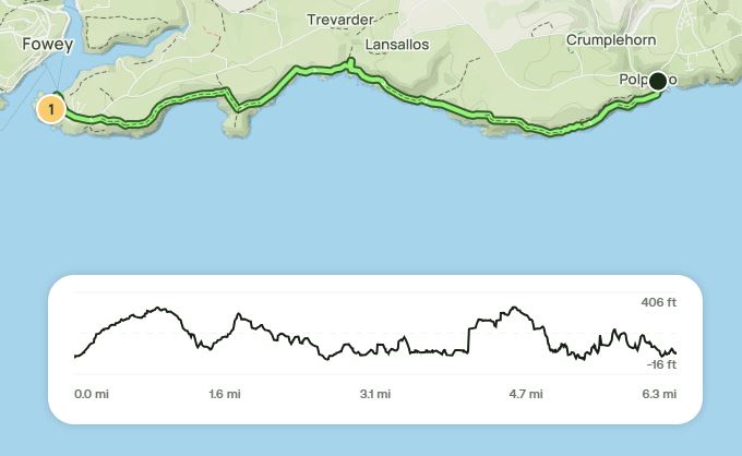
- Start at the dock in Polruan
- Walk up hill to the upper parking lot
- Take the coastal path to Polperro
- Have a beer in the Three Pilchards pub
- Return the same way
- Distance: 15 miles (24.1 km)
- Elevation Gain: 2,728 feet (831m)
- Time: 5 hours
Week 50: Las Trampas
The final training hike and probably the toughest. Killer final ascent in mile 10. From Bollinger Canyon trailhead, around the Rocky Ridge and Carr Ranch Loops. Similar hike to week 42. Facebook Post
- Distance: 11 miles, 17.7 km
- Elevation Gain: 3,173 feet, 967m
- Time: 3h 38m
Week 49: Sunol Wilderness, Las Trampas
Hike 1: Sunol Wilderness. Indian Joe Creek, Maguire Peaks and Flag Hill. Similar to week 41. Facebook Post.
- Distance: 11.9 miles, 19.1 km
- Elevation Gain: 2,497 feet, 761m
- Time: 3h 30m
Hike 2: Las Trampas. Ringtail Cat, Madrone, Las Trampas Ridge, Sulphur Springs, Del Amigo Trails. Similar to week 45. Facebook Post.
- Distance: 10.6 miles, 17.1 km
- Elevation Gain: 2,556 feet, 779m
- Time: 3h 17m
Week 48: Pleasanton Ridge, Reinhardt Redwood
Hike 1: Pleasanton Ridge. Oak Creek, Ridgeline, Shady Creek, Sinbad Creek, Bay Leaf and Thermalito Trails. Similar to week 34. Facebook Post.
- Distance: 13.6 miles, 21.9 km
- Elevation Gain: 2,133 feet, 650m
- Time: 3h 57m
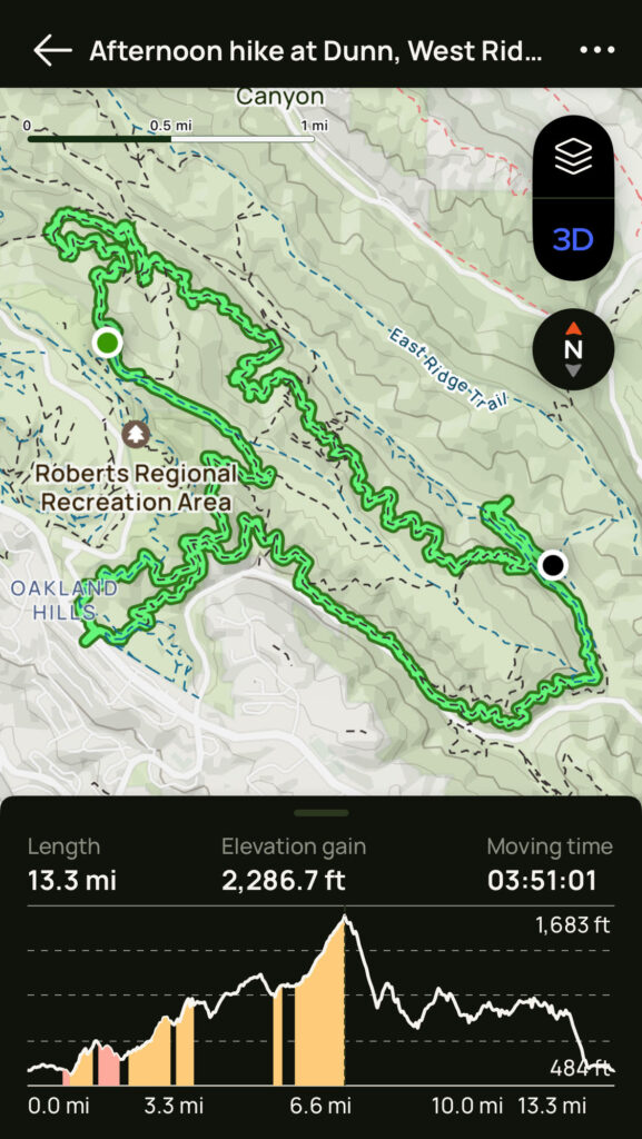
Hike 2: Reinhardt Redwood. Bridal, Golden Spike, Dunn, West Ridge, Redwood Peak, French Trails. Similar to week 32. Facebook Post.
- Distance: 13 miles, 20.9 km
- Elevation Gain: 2,215 feet, 675m
- Time: 3h 45m
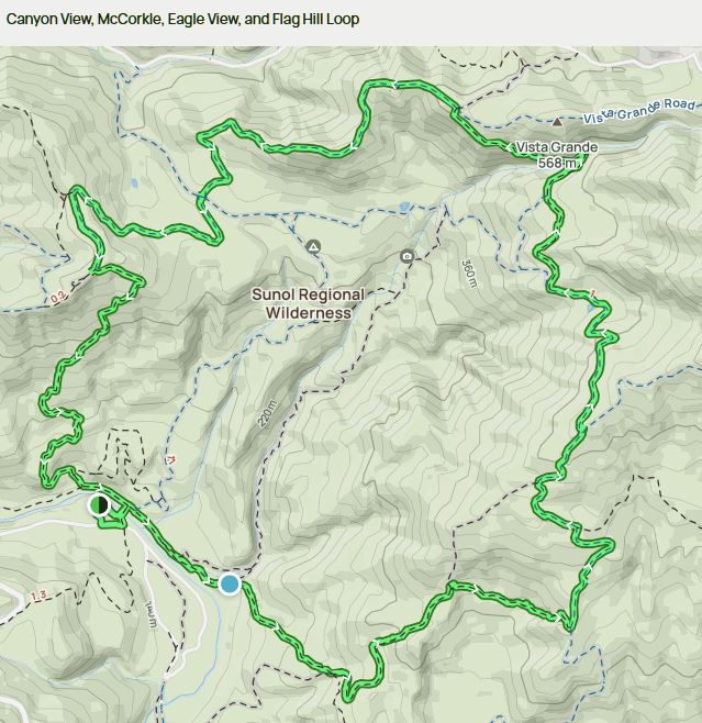
Week 47: Sunol, Joseph D Grant
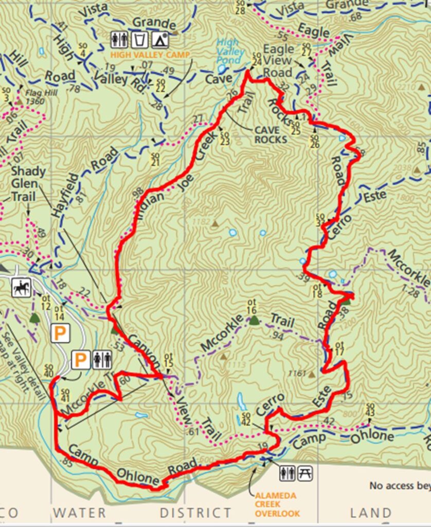
Hike 1: Sunol Wilderness. Little Yosemite, McCorkle, Cerro Este, Flag Hill. Facebook Post.
- Distance: 10.6 miles, 17.1 km
- Elevation Gain: 2,011 feet, 613m
- Time: 3h 10m

- Start at the parking lot near the bridge
- Head out along the Camp Ohlone Road past Alameda Creek Overlook
- Left to Canyon View Trail, then Right to McCorkle Trail
- Continue on Camp Ohlone to park boundary and back
- Left on Cerro Este Road
- Left on Cave Rocks Road, Right on Eagle View Trail
- Eagle View Trail closed, so back to Cave Rocks via Eagle View Road
- Left to Flag Hill Road to Flag Hill
- Down Flag Hill Trail, left then across bridge and back to the parking lot
- Distance: 10.6 miles, 17.1 km
- Elevation Gain: 2,011 feet, 613m
- Time: 3h 10m
Hike 2: Joseph D Grant. Yerba Buena, Canada de Paia, Dutch Flat Loop. Similar to week 43. Facebook Post.
- Distance: 12.3 miles (19.8km)
- Elevation Gain: 2,631 feet (802m)
- Time: 3h 31m
Week 46: Joseph D Grant, Del Valle, Las Trampas
Hike 1: Joseph D Grant. Avenue of the Giants, similar hike to week 13. Facebook Post.
- Distance: 10.3 miles (16.6km)
- Elevation Gain: 1,939 feet (591m)
- Time: 2h 55m
Hike 2: Del Valle. East Shore, Heron Bay and Swallow Bay Trails, similar hike to week 23. Facebook Post.
- Distance: 13.1 miles (21.1km)
- Elevation Gain: 2,621 feet (799m)
- Time: 3h 43m
Hike 3: Las Trampas. Fiddleneck, Las Trampas Ridge, Del Amigo and Sulphur Springs. Facebook Post.
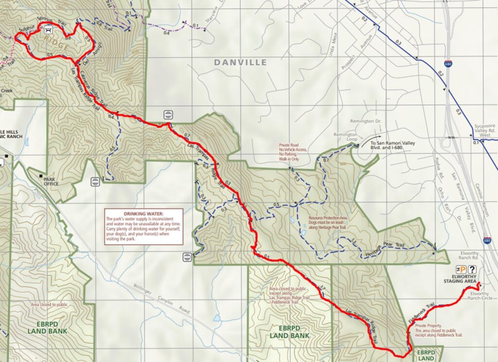
- Las Trampas Ridge to Del Amigo Trail
- Start at the Elworthy Staging Area, parking lot behind housing estate
- Take the Fiddleneck Trail, right onto the the Las Trampas Ridge Trail
- Right to the Del Amigo Trail, then Left to Sulphur Springs Trail
- Left back to the Las Trampas Ridge Trail
- Follow Las Trampas Ridge Trail back the same way
- Distance: 9.2 miles, 14.9km
- Elevation Gain: 2.152 feet (656m)
- Time: 2h 49m
Week 45: Las Trampas, Sunol Ridge, Monument Peak
Hike 1: Las Trampas: Ringtail Cat, Madrone and Las Trampas Ridge. Facebook Post.
- Distance: 10.6 miles (17.1km)
- Elevation Gain: 2,562 feet (781m)
- Time: 3h 18m
Hike 2: Pleasanton Ridge: Tyler Ranch, Sunol Ridge, Woodside Spring. Facebook Post.
- Distance: 8.7 miles (14km)
- Elevation Gain: 2,205 feet (672m)
- Time: 2h 48m
Hike 3: Ed Levin to Monument Peak and Bay Area Ridge Trail. Facebook Post
- Distance: 11.9 miles (19.1km)
- Elevation Gain: 2,523 feet (796m)
- Time: 3h 30m
Week 44: Reinhardt Redwood, Vargas Plateau, Sunol to Mission Peak
Hike 1. Palos Colorados, Big Trees, Redwood, Stream, Castlepark. Same hike as week 24.
- Distance: 13 miles (20.9km)
- Elevation Gain: 2,274 feet (693m)
- Time: 3h 59m
Hike 2. Vargas. Deer Gulch, Cliff Trail, Deer Gulch spur, Upper Ranch Loop.
- Distance: 10.1 miles (16.3km)
- Elevation Gain: 1,683 feet (513m)
- Time: 2h 45m
Hike 3. Sunol Wilderness to Mission Peak. Same hike as week 25.
- Distance: 10.9 miles (17.5km)
- Elevation Gain: 2,320 feet (707m)
- Time: 3h 13m
Week 43: Del Valle. East Lasso to West Beach via East Shore
First Del Valle hike starting from the park main entrance. East Shore and Heron Bay trails. Coyote, Heron, Western Grebe, Rattlesnake, other unidentified snake. Long but no long difficult climbs. Quite a few hikers and bikers.
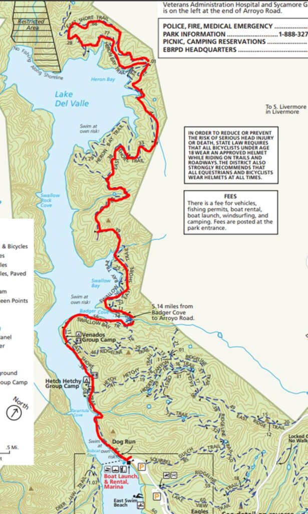
- Start at the parking for the Boat Ramp/Marina
- Take the East Shore Trail, past Venados Group Camp
- Left to Heron Bay Trail (5 miles), Right to rejoin East Shore Trail (6 miles)
- Follow East Shore Trail back to parking lot
- Distance: 11.9 miles (19.1km)
- Elevation Gain: 1,721 feet (525m)
- Time: 3h 6m
Week 43: Joseph D Grant. Yerba Buena, Canada de Paia and Dutch Flat Loop
Fourth trip to Joseph D Grant, this time a loop to the south of Grant Lake. Long ascent for the first 2 miles, and more towards the end. Baby garter snake the only wildlife, no fellow hikers. Facebook Post.
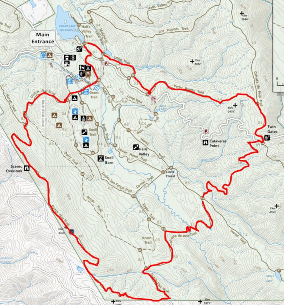
- Start from the Grant Lake trailhead on Mt Hamilton Road (130)
- Right to the Lake View trail, at McCreery Lake continue on the McCreery Lake trail
- Left to the Loop Trail, then Left to the Yerba Buena Trail
- Bear Right to the Canada de Paia Trail, cross 130 to the Bonhoff Trail
- Immediate Right back onto the Canada de Paia Trail
- Becomes the Dutch Flat Trail. Left to the Hotel Trail, Left to the Yerba Buena Trail back to the trail head
- Distance: 12.5 miles (20.1km)
- Elevation Gain: 2,657 feet (810m)
- Time: 3h 51m
Week 42: Las Trampas. Carr Ranch and Rocky Ridge Loops
Second trip to Las Tramps. This time from the Bollinger Canyon trailhead. Long steep ascents from the trailhead, and again on the final ascent of the Rocky Ridge Trail. Saw coyote and turkey. Facebook Post.
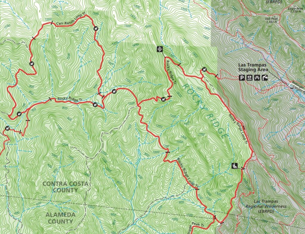
- Start on the trailhead at the Bollinger Canyon Trailhead
- Head out on Rocky Ridge View (road), bear Left to Rocky Ridge View Trail
- Right to Rocky Ridge Loop Trail, Right on Rocky Ridge Trail at Callahan Road
- Right to Carr Ranch Loop Trail, becomes Rocky Ridge Trail
- Continue on Rocky Ridge Trail at junction with Rocky Ridge Loop Trail
- Becomes Rocky Ridge Loop Trail, Right to Rocky Ridge View Trail back to trailhead
- Distance: 11 miles (17.7km)
- Elevation Gain 3,153 feet (961m)
- Time: 3h 31m
Week 41: Pleasanton Ridge. Courdet, North Ridge, Mariposa, Sinbad Creek, Turtle Pond Loop
Another enjoyable hike on Pleasanton Ridge. Started with the AllTrails hike above, but added a loop from North Ridge, down Loop Trail, along Sinbad Creek and back up Shady Creek trail.
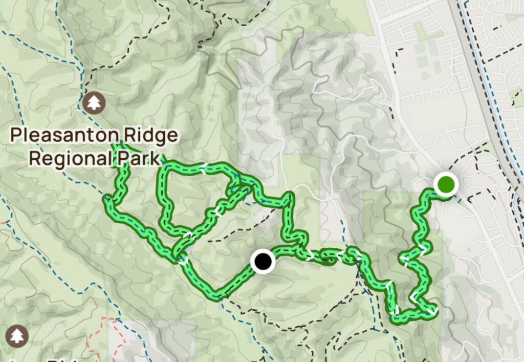
- Start at the Castleridge trailhead, 3464 Old Foothill Road, Pleasanton
- Take the Courdet Trail, Left on Ridgeline Trail, then immediate Right
- Veer Right to join Shady Creek Trail, then Left to North Ridge Trail
- Left on Mariposa Trail, Left to Sinbad Creek Trail, then Right on Turtle Pond Trail
- Right on North Ridge, then Right to Loop, down to Sinbad Creek, turn Left
- Right on Shady Creek Trail, Right back to North Ridge Trail and return the same way to the trailhead
- Distance: 11.2 miles (18km)
- Elevation Gain: 2.090 feet (637m)
- Time: 2h 57m
Week 41: Sunol Wilderness. Indian Joe, High Valley, Welch Creek, Maguire Peaks
Slightly different route up to the Maguire Peaks Loop than previously. Amazing to see how the area has recovered from last July’s fire. Facebook Post
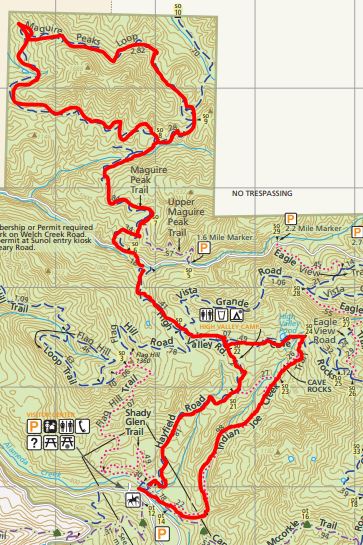
- From the visitors center, across the bridge and Right to Canyon View Trial/Indian Joe Creek Trail
- Left to Cave Rocks Road, bear Right to High Valley Road
- Right to Maguire Peaks Loop, around loop Right back to High Valley Road
- Right to stay on High Valley, becomes Hayfield Road. Left to bridge and parking lot
- Distance: 11.9 miles (19.2km)
- Elevation Gain: 2,464 feet (751m)
- Time: 3h 19m
Week 40: Diablo, Eagle Peak and Black Point Loop
Very tough gain of almost 2,000 feet to Eagle Peak via Twin Peaks in the first 2.5 miles on a rough rocky trail, almost treacherous in places. Followed by long steep slippery downhill on the wide Deer Flat Road. Skipped the Black Point loop. Not my favorite hike. Facebook Post.
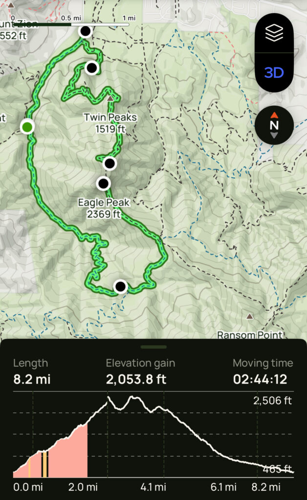
- Start at Mitchell Canyon Visitor Center Parking Lot on Oak Road
- Right to Mitchell Rock Trail, Past Twin Peaks, keep Right to Eagle Peak Trail
- At 3.4 miles bear Right to Meridian Ridge Road then Right to Mitchell Canyon Road
- I skipped Black Point
- At 6.8 miles Left to Red Road, then Right to Black Point Trail
- Detour to Black Point, then continue down and Left on Mitchell Canyon Road at 9.9 miles
- Follow Mitchell Canyon Road back to the parking lot
- Distance: 8.2 miles (13.2km)
- Elevation Gain: 2,104 feet (641m)
- Time: 2h 44m
Week 39: Ed Levin Park to Mission Peak via Monument Peak
Week 38 was reduced to 3, 4-mile walks with Wally in Santa Barbara as I went down with a nasty cold. Same hike as week 35, with an alternative ascent to Monument Peak. Facebook Post.
- Distance: 14.3 miles (23km)
- Elevation Gain: 3,186 feet (971m)
- Time: 4h 18m
Week 37: Oyster Point, Morgan Territory and Mount Diablo Regional Park
Hiked the length of Oyster Point Trail from Old Finley Road to the Black Hawk Ridge Trail. Muddy and slippery in places after the recent rain. Witnessed a Bobcat hunt down a ground squirrel for lunch. Facebook Post. Next day easy consecutive hike around Coyote Hills: Apay Way, Bay View and Red Hill trails (6.8 miles, 636 feet, 1h 42m)
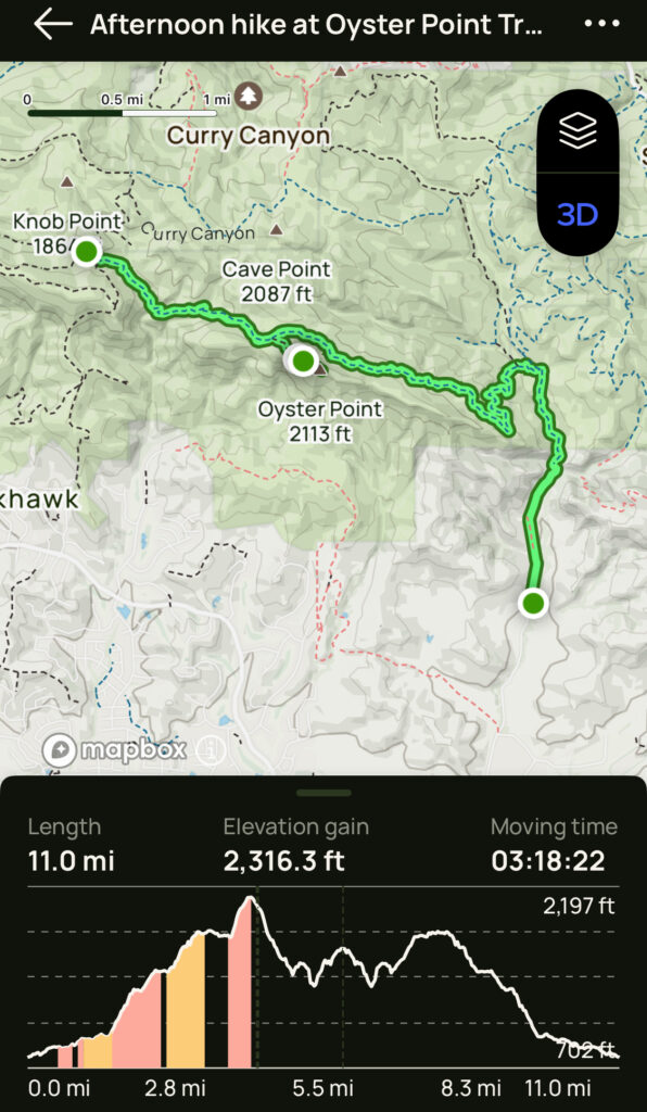
- Morgan Territory, Oyster Point Trail
- Start at the Finley Road Trailhead (roadside parking ¾ mile South of trailhead)
- Head out on Old Finley Road, turn Left to Oyster Point Trail at 1.4 miles
- Detour Right to Oyster Point at 3.8 miles
- Continue to mile 5.6, the junction of Black Hawk Ridge Road
- Return the same way back to the staging area
- Distance: 11 miles (17.7km)
- Elevation: Gain 2,316 feet (578m)
- Time: 3h 18m
Week 36: Garin Regional Park
Hiked three loops in Garin park to get a reasonable mileage and elevation gain. This is one of the TC2025 challenge hikes. Steep initial climb from the visitor center (up to 38%), then mostly gentle. Facebook Post.
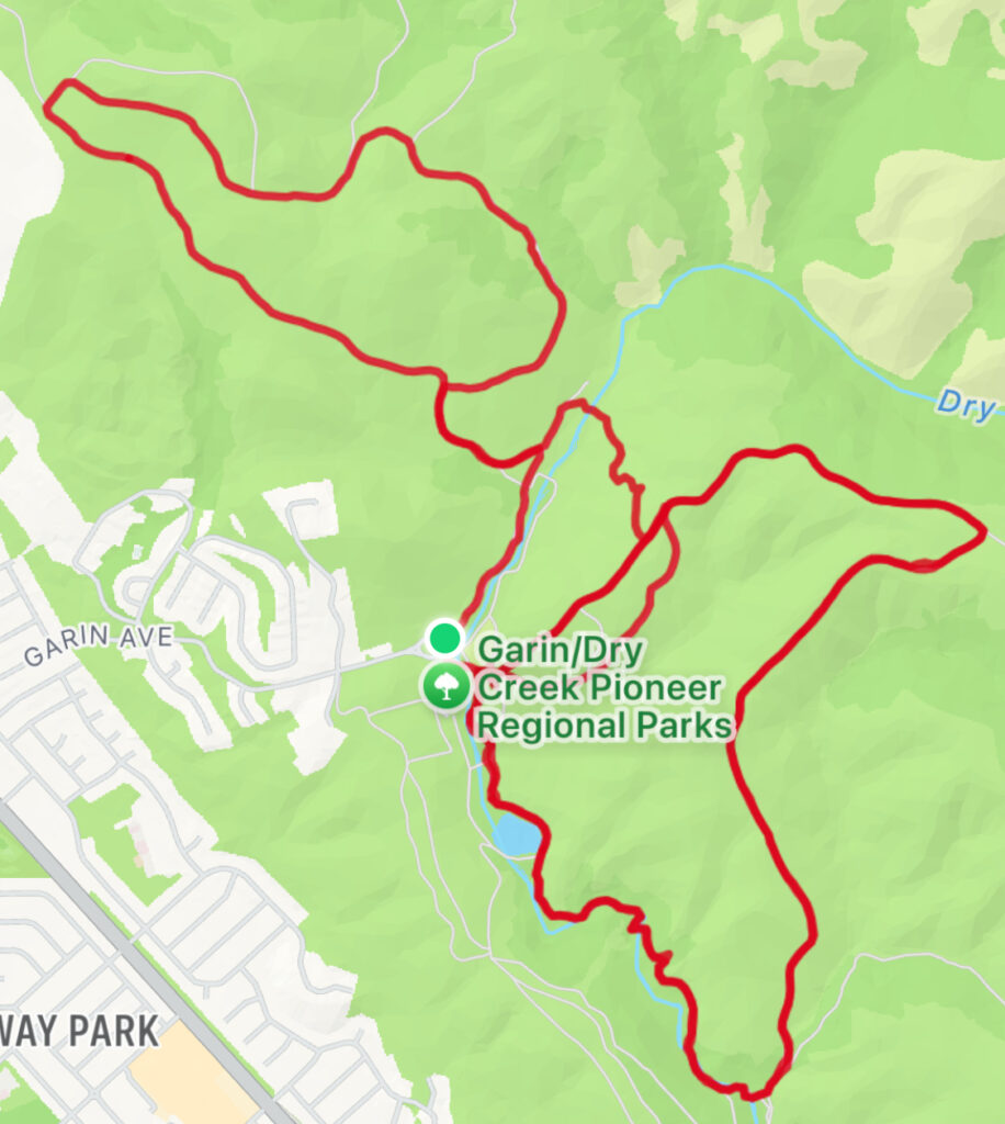
- High Ridge, Meyers Ranch and Dry Creek Trail (Twice)
- Start at the Garin Visitors Center
- Keep Left on to the High Ridge Loop trail
- At the summit sharp Right on the Meyers Ranch Trail
- Left on to the Dry Creek Trail
- Keep Right of the Jordan Pond back to the parking area
- High Ridge, Newt Pond and Vista Peak Loop
- Start at the Garin Regional Park Visitor Center
- Restrooms to your left walk forward through the cattle gate the Newt Pond Trail loop
- Right on Old Homestead Trail and Right to join the Vista Peak Loop Trail
- Keep Left on Vista Peak Trail, then Right to get back to Old HomeStead, Newt Pond Trails back
- Distance: 10.8 miles (17.4km)
- Elevation: Gain 2.293 feet (699m)
- Time: 3h 4m
Week 35: Mission Peak from Ed Levin County Park
My fourth different route to Mission Peak. This time from the Sandy Wool trail head in Ed Levin park. Tough first 3.5 miles to Monument Peak, the final climb had ridiculous grades over 30%. Facebook Posting
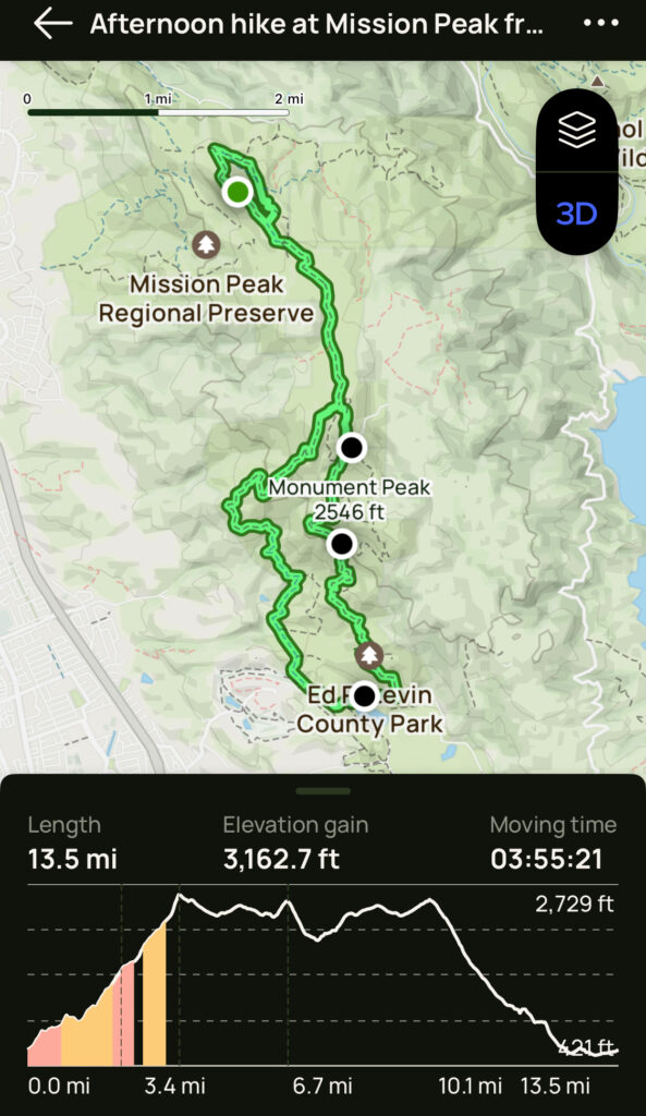
- Start in Sandy Wool lake area, Tularcitos Trailhead parking by dog park
- Start on Tularcitos Trail, at #15 left to Agua Caliente Trail
- Pass #5 and #18 taking Monument Peak Trail past #21 to Monument Peak
- Continue on Weller Road, then Right on to the Bay Area Ridge Trail
- Continue on the Bay Area Ridge Trail, then Left on Peak Trail to Mission Peak
- Carry on the Peak Trail then Right on to the Eagle Trail
- Pass the Eagle Spring Backpack Camp then Left on the Bay Area Ridge Trail
- At Weller Road turn Right to continue on Bay Area Ridge Trail
- Continue down at #9 join Agua Caliente and Calera Creek Trails to Sandy Wool lake
- Distance: 13.5 miles (21.7km)
- Elevation: Gain 3,163 feet (964m)
- Time: 3h 55m
Week 34: Pleasanton Ridge Regional Park
Back to the Regional Park, but further south than my previous week 29 hike. Starting at the Foothill Staging Area, I took the Pleasanton Ridge to Shady Creek to Bay Leaf Trail hike. Warm, sunny day: mostly moderate uphill sections, some small streams crossing the trails, but little mud. Facebook Posting.
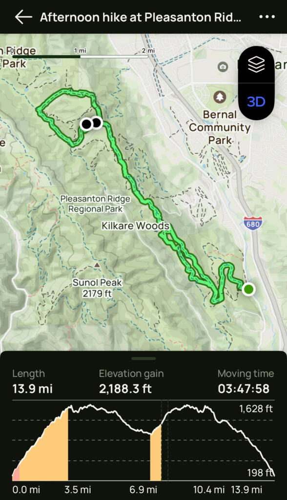
- Start at the Foothill Staging Area just off 680 near Sunol
- Head out on Oak Tree Trail, Right on to Ridge Line Trail
- Left on Shady Creek Trail, then Left on to Sinbad Creek Trail
- Left on Bay Leaf Trail, then Right back to Ridge Line Trail)
- Right on to Thermalito Trail, then Left on to Olive Grove Trail
- Right on Ridge Line Trail, then Left on Oak Tree Trail back to the staging area
- Distance: 13.9 miles, 22.4 km
- Elevation Gain: 2,188 feet, 667 m
- Time: 3h 47m
Week 33: Joseph D Grant Park
Back here again on the Avenue of Giants Trail. Same hike as week 13.
- Distance: 11.1 miles (17.9km)
- Elevation Gain: 2,037 feet (621m)
- Time: 3.1 hours
Week 32: Reinhardt Redwood Region Park
Second hike in this park, a perfect between rain hike location: wet but no serious mud. Started at the Canyon Meadow Staging Area rather than Skyline Blvd where there have been reports of multiple car break-ins. Bald Eagle spotted soaring above the Dunn trail near Skyline Blvd.
- Started at Canyon Meadow Staging Area rather than Skyline Blvd
- Along Stream trail, and crossed the stream to Bridal Trail to join the Alltrails loop hike
- Follow West Ridge and Golden Spike trails to Skyline Blvd (where there is an excellent view of the bay)
- From Skyline Blvd, take Dunn and Redwood Peak trails to Redwood Peak (spot the triangulation marker!)
- Then take the French, Tres Sendas, Starflower and French Trail again
- This becomes Orchard trail, then left and return to the staging area via Bridal and Stream Trails
- Distance 13.3 miles (21.4km)
- Elevation Gain 2,286 feet (697m)
- Time 3h 51m
Week 31: Morgan Territory Regional Preserve
Back from England where the only hiking was about 30 miles along various river Thames paths (no elevation gain!) to real hiking. Another new place for me, the Morgan Territory Regional Preserve. Typical East Bay scenery: oak woods, grassy hillsides, also lots of Horse Chestnut trees and Conkers. Facebook Post.
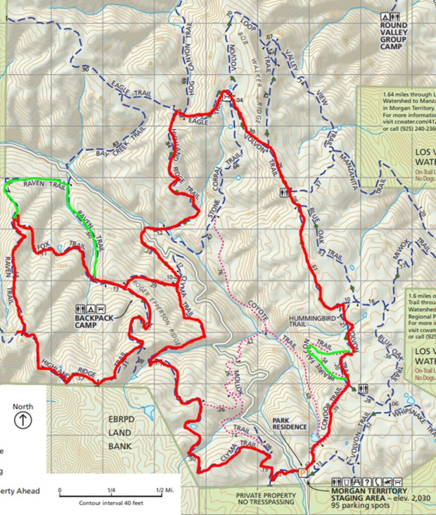
- Morgan Territory: Clyman, Highland Ridge, Raven, Fox, Eagle, Volvon and Condor Trail Loop
- Start at the Morgan Territory Staging Area (580, N Livermore Ave, Morgan Territory Road)
- Take the Clyma trail, then Left on Highland Ridge trail and Left again to stay on Highland Ridge Trail
- Right on the Raven Trail, Right on Fox trail and back to the Highland Ridge Trail
- Left to stay on Highland Ridge Trail, Right on Eagle Trail, Right on Volvon Trail
- Detour loop out the Prairie Falcon Trail and back
- Continue on Volvon Trail, becomes Condor trail back to staging area
- Distance 10.4 miles (16.7km)
- Elevation Gain 2.037 feet (621m)
- Time 2h 58m
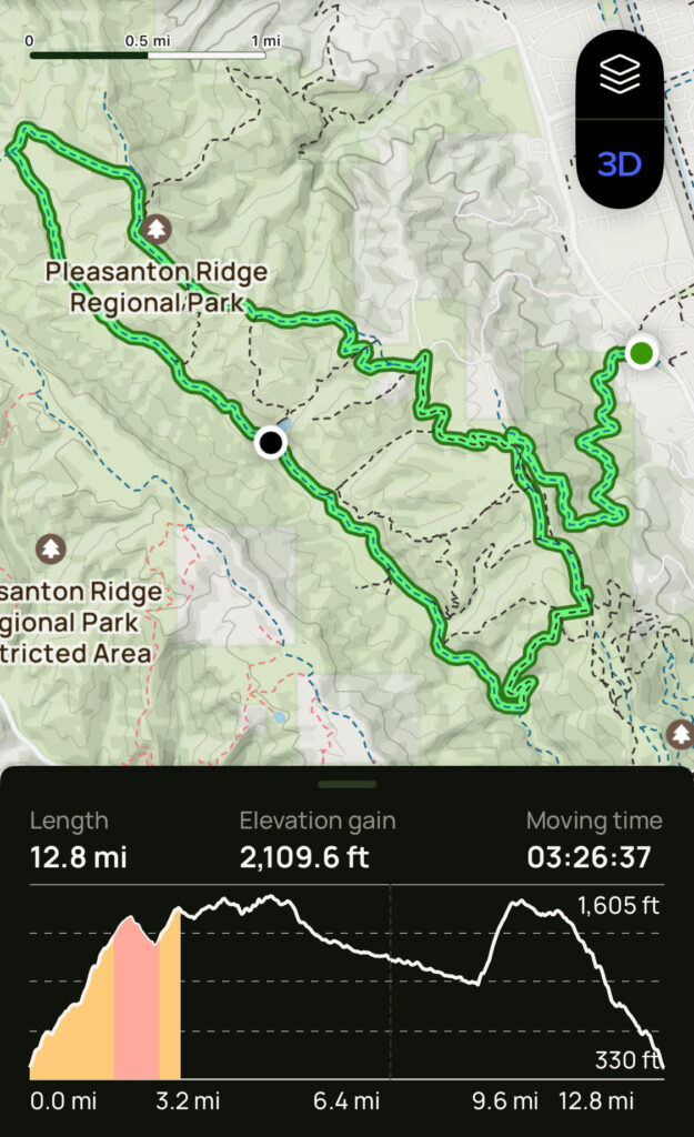
Week 29: Pleasanton Ridge Regional Park
First hike of 2025 in Pleasanton Ridge Regional Park. Another clear and sunny day but this time up to 66F. Started with a long climb out of the trailhead, long flat 3.5 mile middle section along Sinbad Creek followed by a very steep final climb out of the valley. Saw my first bobcat. Facebook Post.
- Start at the Castleridge Trailhead on Foothill Road take the Courdet Trail up hill
- Turn left, go about two hundred feet, and then turn right onto Ridgeline Trail
- Turn right onto Shady Creek Trail
- Go left on North Ridge Trail. Pass Loop Trail, continuing on North Ridge Trail
- Pass through a cattle gate, and, at mile 4.8, turn left onto Cowing Trail
- Turn left onto Sinbad Creek Trail which leads through Kilkare Canyon
- Follow Sinbad Creek Trail for about 3.5 miles. Left at mile 9.0 the trail splits (marker 23), and follow Sinbad Creek Trail uphill
- Take a left on Ridgeline Trail. Follow Ridgeline Trail until you reach Courdet Trail
- Turn right on Courdet Trail and descend two miles back to the trailhead
- Distance 12.8 miles (20.6km)
- Elevation Gain 2,110 feet (643m)
- Time 3h 27m
Week 28: Las Trampas Wilderness, Ringtail Cat to Madrone Trail
Last hike of the year in Las Trampas Wilderness in Alamo. Another clear, sunny winter day, but cool (started at 44F). Quite muddy in areas where cattle have been. Saw no cats (ringtail or other), just deer. Facebook Post
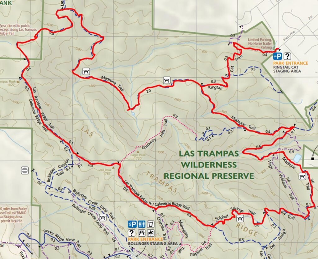
- Start at the Ringtail Cat Staging Area, head out along Ringtail Cat Trail
- Right on to Madrone Trail after 1 mile
- Left on to Las Trampas Ridge and Calaveras Ridge Trail, stay on past Vall Peak to the right
- Left on to Sulphur Springs Trail, becomes Del Amigo Trail at mile 6.9
- At mile 7.4, left on to Madrone Trail
- Right on Ringtail Cat Trail back to the staging area
- Distance 10.5 miles (16.9km)
- Elevation Gain 2,592 feet (790m)
- Time 3h 22m
Week 27: Sunol Wilderness Little Yosemite and Indian Jose Creek
Post Christmas hike with Mark, Morgan and Max. Level hike out to Little Yosemite, then long uphill stretch on Cerro Este Road which was mainly loose gravel and mud. The slow pace number is a little distorted by several stops for Max to wade in water. Facebook Post
- Start at the bridge parking area in Sunol Wilderness
- Take Camp Ohlone trail to Little Yosemite
- Left on Cerro Este Road uphill to Outlook, then left on Cave Rocks Road
- Down Indian Joe Creek Trail past Indian Joe rocks
- Take Canyon View Trail and McCorkle Trail back to bridge
- Distance 6.2 miles (10km)
- Elevation 1,627 feet (496m)
- Time 2h 30m
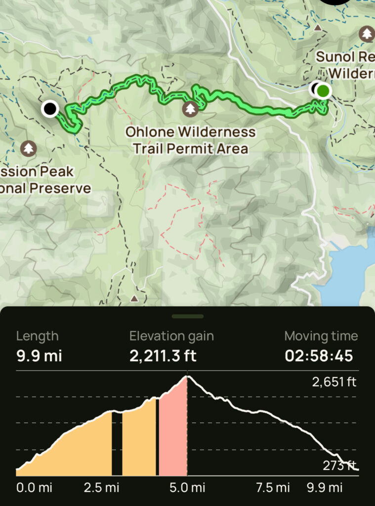
Week 25: Sunol Wilderness Regional Park to Mission Peak
I have done Mission Peak from Stanford Ave and Ohlone College, but this is by far the most pleasant route (and the longest at 10 miles round trip). The first 3 miles is mainly through oak woods. It’s a long gradual 5 mile ascent with a few steep sections, but that’s what it takes to get to Mission Peak. Herd of 6 deer spotted on Eagle Trail just behind Mission Peak Facebook Post
- Start at Sunol Regional Parking lot, across from the Visitor Center (not behind it)
- Follows the Ohlone Wilderness Trail 5 miles up to Mission Peak (permit required)
- Turn left as you approach the back of Mission Peak along Eagle Trail
- Pass the Eagle Springs Backpack Camp then turn right and ascend to the top of Mission Peak
- Return the same way back to the Sunol Parking lot
- Distance 9.9 miles (15.9km)
- Elevation Gain 2.211 feet (674m)
- Time 2h 59m
Week 24: Joaquin Miller and Reinhardt Redwood Parks
A new hiking area for me in the Oakland hills, Joaquin Miller and Reinhardt Redwood Parks. Almost the whole way was sheltered through wooded areas: Redwoods, Eucalyptus and Oak trees. Difficult to follow the Alltrails route because there were so many short sections of other trails not listed below. On the Stream Trail was the spot where ladybugs winter, thousands of them. Facebook Post
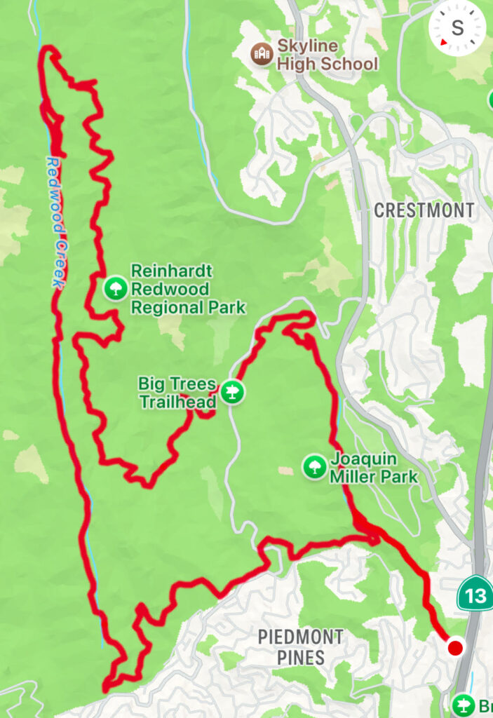
- Start at the Palos Colorados trailhead, taking the Palos Colorados Trail
- Right onto the Sinawik Trail, then Big Trees, Camp, Redwood Peak, French Trails
- Left onto Bridle Trail, Stream Trail
- Left at Skyline Gate Staging Area to West Ridge Trail, Castle Park Trail
- Right on to Palos Colorados trail and return to trailhead
- Distance 13 miles (20.9km)
- Elevation Gain 2,274 feet (693m)
- Time 4h 13m
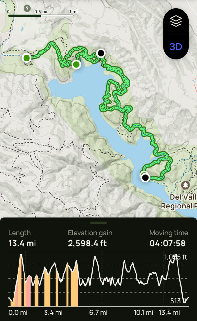
Week 23: Del Valle Regional Park, Arroyo Road to Venados
My first hike at Del Valle, from the Arroyo Road Staging Area to the Venados Camping site. Another clear but cool day with a refreshing breeze, ideal for hiking. Going around the North East side of the reservoir with a lot of ascents and descents throughout the hike. East Shore Trail is wide with fine gravel surface, the Heron Bay Trail much narrower and more interesting, winding through oak groves. Facebook Posting.
- Start at the Arroyo Del Valle Staging Area on Arroyo Road
- Take the East Shore Trail turning right towards the Heron Bay Trail
- Stay on the Heron Bay and East Shore Trails (closest to the lake)
- Heron Bay Trail merges with East Shore Trail
- Follow East Shore Trail all the way to Venados Group Camp
- Return keeping to the East Shore and Heron Bay Trails back to the Staging area
- Distance 13.4 miles (21.6km)
- Elevation Gain 2,598 ft (792m)
- Time 4h 8m
Week 22: Sunol Wilderness and Maguire Peaks
Back from travel to San Antonio that scuppered weeks 20 and 21 training, this week in Sunol Wilderness and up to the Maguire Peaks. Cool but clear and sunny weather made for ideal hiking. The damage from the wildfire a couple of months back was quite minimal, not noticeable from most of the hike. Facebook Posting
- Park at Sunol Regional Park HQ
- Right after bridge and take Indian Joe Creek Trail, past the rocks, left on Cave Rocks Road
- Take High Valley Road and Maguire Peak Trail to the Maguire Peaks Loop
- After the loop descend the same way, but then turn right on to Flag Hill Road
- From Flag Hill descend the steep Flag Hill Trail to the visitor center
- Distance 11.1 miles (17.9km)
- Elevation Gain 2,487 ft (758m)
- Time 3h 27m
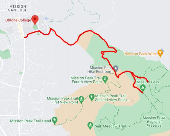
Week 19: Ohlone College to Monument Peak
Another hike in the East Bay today. Perfect weather, cool but sunny with a refreshing breeze in exposed areas. Starting from Ohlone College, hiked up Mission Peak then continued south to Monument Peak, the same destination as last week. Coming back I took a detour on Eagle Trail around Mission Peak. New personal bests for distance, elevation and pace. Facebook Post
- Park on Mission Boulevard near Ohlone College
- Take the Peak Trail to Mission Peak
- Continue on to the Bay Area Ridge Trail, then left at mp2 marker to Monument Peak
- Return the same way, but taking the Eagle Trail Loop around the back of Mission Peak
- Then return on the Peak Trail to parking spot
- Distance 12.2 miles (19.7km)
- Elevation gain 2,607 feet (794m)
- Time 3h 38m
Week 18: Ed Levin Park to Monument Peak
Cooler weather so back in the East Bay hills, hiking from Ed Levin Park in Milpitas to Monument Peak (a couple of peaks south of Mission Peak). Topped the elevation gain again at 2,274 feet (693m), but still not one day of Mont Blanc hike’s average 1,000m. Many raptors (mainly red tailed hawks and turkey vultures) and a pair of coyote close to Sandy Wool Lake. Facebook Link
- Start at the Tularcitos trailhead parking lot near Sandy Wood lake
- Take the Tularcitos, Monument Peak and Sierra Trails to Monument Peak Road
- Take Monument Peak Road to the Peak and then to the Bay Area Ridge Trail
- Continue down Agua Calente and Calera Creek Trails back to the parking lot
- Took a detour stroll around Sandy Wool Lake
- Distance 9.8 miles (15.7 km)
- Elevation Gain 2,274 feet (693m)
- Time 3h
Week 17: Sanborn County Park
Week 15 and 16 training hikes were cancelled due to an excessive heat warning (just about all the bay area was over 100F) and Mark’s wedding respectively.
Week 17 saw me back at Sanborn County Park, in the cool and shade of the Redwood, Beech and Oak trees. A late start and long hike meant I did not have time to visit the nearby Loma brewing company. This was the largest elevation gain of any hike so far at 2,222 feet (677m), even more than Mission Peak. Facebook posting
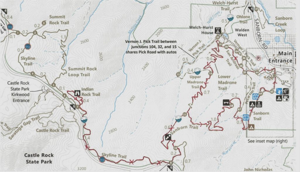
- Start at the Sequoia parking lot next to park entrance
- Take Nature Trail and Peterson Trail to San Andreas Trail
- Long uphill on Lower and Upper Madrone Trails to Skyline Trail
- Along Skyline trail to Indian Rock loop (Summit rock is another 2 miles!)
- Back along Skyline Trail and Sanborn Trail to parking lot
- Distance 10.1 miles (16.3km)
- Elevation gain 2,222 feet (677m)
- Time 3h 30m
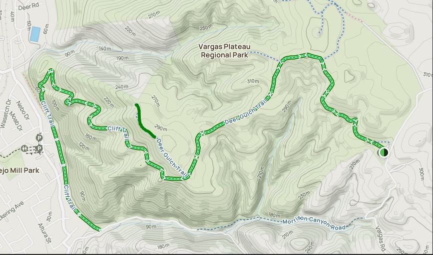
Week 14: Vargas Plateau (again)
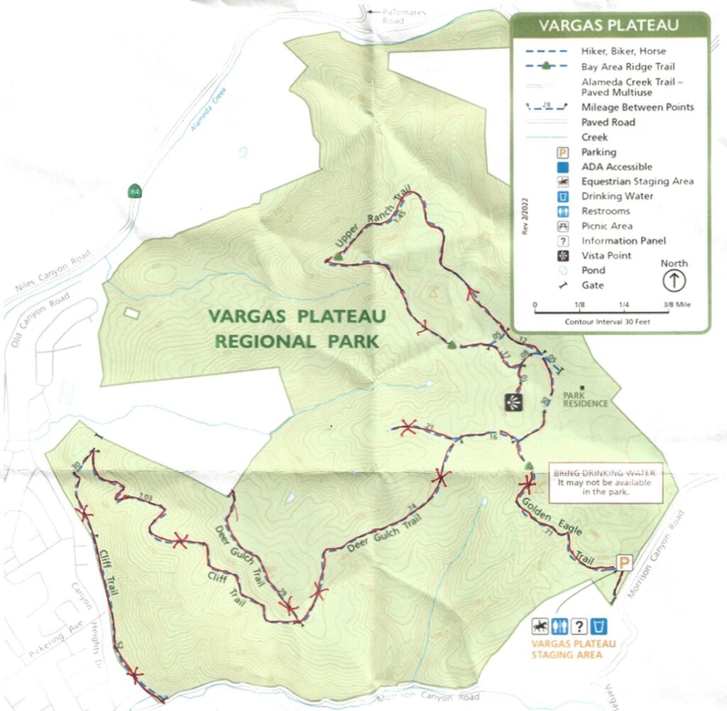
- The first section is the same as Training Week 4: Golden Eagle, Deer Gulch and Cliff trails
- Detour on the return leg around the Upper Ranch Trail
- Facebook link
- Distance 9.4 miles (15.2 km)
- Elevation Gain 1,426 feet (435 m)
- Time 2h 50m
Week 13: Joseph D Grant County Park (again)
September 18: Disappointed by the mount of paved hike last week, I returned to Grant park for a second hike. The “Avenue of the Noble Giants” did not disappoint. Great hike with lots of wild life (deer, tarantulas, baby gopher snakes, golden eagles …) and again no other hikers. Après hike beverages at Mission Pizza. Facebook Posting

- Start at Grant Lake Trailhead in Joseph D Grant County Park
- Short way along Halls Valley Trail, then right on to Los Huecos trail
- Left on to Canada de Pala trail, then left on to Pala Seca trail
- 1.2 mile there and back detour to Antelope Point, lunch on the park bench at he detour
- Continue on Canada de Pala trail, join Halls Valley trail back to trailhead
- Distance 11.3 miles (18.2 km)
- Elevation Gain 1,774 feet (541m)
- Time 3h 30m
Week 12: Joseph D Grant County Park
September 10: A cooling trend this Tuesday, so back to the South East bay. My first trip to the Joseph D Grant County Park on Mt Hamilton Road. Saw golden eagles and wild boars, but no other hikers. Stopped by the IBU Taproom in Milpitas on the way back: nice cider but pricey, too modern and empty inside. Facebook Posting
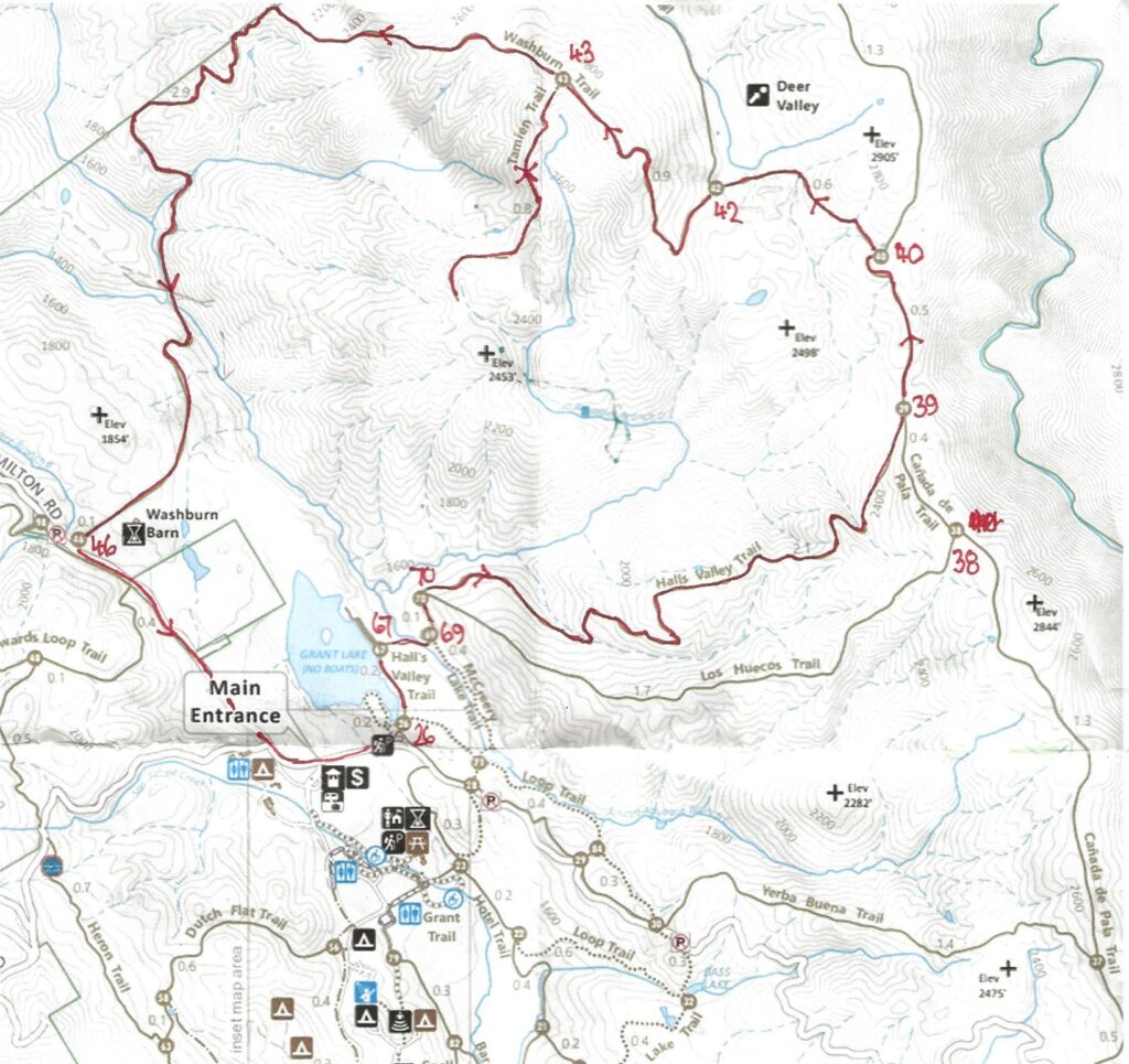
- Start at Grant Lake Trailhead in Joseph D Grant County Park
- Along side the lake on Halls Valley Trail
- Right on to Hall’s Valley trail, two miles up hill and mostly through oak forests and woodlands
- Tees into the Canada de Pala trail at the top, make a left, continue going up
- Left branch of the Pala Seca trail to the Washburn trail
- Left on to the Washburn trail, mostly downhill but too much paved road
- Join Mt Hamilton Road for a mile back to the start
- Distance 8.7 miles (14km)
- Elevation gain 1,754 feet (534m)
- Time 2h 42m
Week 11: Bear Creek Redwoods Open Preserve
September 4. Another scorcher in the East Bay forced me south to the shade of Bear Creek Redwoods, just south of Los Gatos. Nice hike almost all shaded through woods and redwoods. Long gradual ascent with no really steep sections. Met about 2 hikers each mile. Ended the morning with a cider at the Loma Brewery in Los Gatos: my first ever visit to downtown Los Gatos! Facebook Posting
- Start at the Bear Creek Redwoods parking lot
- Back across Bear Creek Road to the Alma Trail
- Keep left at the junction with Redwoods Spring Trail
- Stay on the Alma trail until the junction with the Madrone Knoll Trail
- Take the Madrone Knoll Trail to the peak and back
- Return down the Redwoods Spring Trail
- Turn left on to the Alma trail back to the parking lot
- Distance 7.4 miles (11.9 km)
- Elevation gain 1,596 feet (486 m)
- Time 2h 17m
Week 10: Sanborn County Park
August 27. Another long drive to Sanborn county park, just past Saratoga off highway 9. Nice hike in the trees with gradual climbs (steeper descents) and no exposed sections. Impressive grove of redwoods in the Creek off the Sanborn trail. Met eight bikers on the way up the John Nicolas trail, but not a single hiker all day. Facebook posting
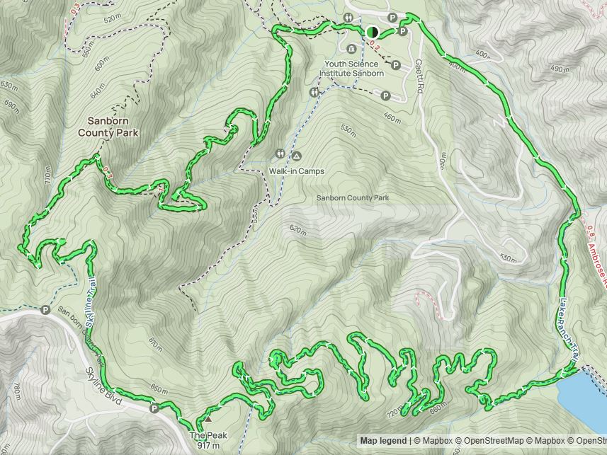
- Start at Sanborn County Park entrance
- Continue along Sanborn Road for about a mile
- At the end of the road take the Lake Ranch Trial to the right
- Uphill on Lake Ranch and John Nicolas trails to Skyline Trail
- Downhill on the Sanborn and Peterson Memorial trails back to the park entrance
- Distance 9.32 miles (15 km)
- Elevation gain 1,896 feet (578 m)
- Time 2h 55m
Week 9: Rancho San Antonio Park
August 20: South bay to Cupertino and the Rancho San Antonio County Park for the first time. A one hour drive during commute hours to get there (return in 35 minutes). Started with a short detour around Deer Meadow Trail (and yes, I saw a deer). Quite busy until I got past Deer Hollow Farm, then occasional hikers. Facebook posting
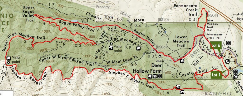
- Start at one of the parking lots of Rancho San Antonio County Park
- Set out along Permanente Creek Trail and go around the Deer Meadow Trail
- Out along Lower Meadow Trail past Deer Hollow Farm
- Then gradual long uphill on Rogue Valley, Upper Rogue Valley and Upper High Meadow Trails
- Steep final stretch up to the Vista Point with views across the valley
- Return down Stephen E. Abbors (quite steep descent near the top) and Coyote Trails to the parking lot
- Distance 10.2 miles (16.4km)
- Elevation Gain 1,539 feet (468m)
- Time 3h 4m
Week 8: El Corte de Madera Creek
August 16. Across the Bay to the El Corte de Madera Creek open preserve on Skyline Boulevard in Redwood City. Took over a hour to get there, so probably won’t go back for a while. Leisurely hike with Alison, almost completely in the shade and few steep sections. Stopped at the interesting erosion patterns on the Tafoni sandstone formation. This area was the site of worst aircraft crash in San Mateo when a DC9 crashed killing all 19 aboard. Facebook posting
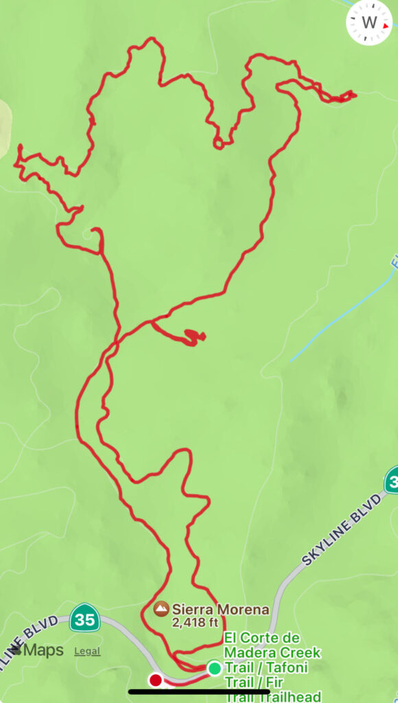
- Starting at the Skeggs Point parking lot on Skyline Boulevard
- Gradual descent up the Tafoni trail to the Tafoni sandstone outcrop
- Continue up the Tafoni Trail to the El Corte de Madera trail
- Return mainly downhill on the Resolution and Fir trails
- Short detour to the Vista Point near the Resolution memorial: the view was not that impressive
- Distance 5.5 miles (9km)
- Elevation Gain 718ft (219m)
- Time 2h 45m
Week 7: Sunol Ridge and El Corte de Madera
August 13. My first time to Tyler Ranch, one of the newest East Bay Regional Parks. The Tyler Trail from the trailhead meanders up the hill with many cut backs to join the Sunol Ridge Trail. Then brutal continuous, exposed and windy (as in blowing hard not meandering) uphill stretches to Sunol Peak. Breakfast on the pleasant Woodside Spring trail under the trees. Only one other hiker on the trail. Unfortunately Bosco’s Roadhouse was closed, I could have used a beer after the hike. Facebook posting

- Starting at the Tyler Ranch trail head just outside Sunol
- Wind up the Tyler Ranch trail to join the Sunol Peak trail
- Long uphill stretches towards Sunol peak
- Shortly before the Peak, detour around the peak on the Woodside Spring trail
- Repeated the detour to add another mile or so
- Distance 9 miles (14.5km)
- Elevation Gain 2,254ft (687m)
- Time 3h
Weeks 5 and 6: West Tiger Mountain
August 2 and 5. Two hikes in the West Tiger Mountain area during our vacation in Seattle. Both starting and finishing at the East Sunset Way Trailhead in Issaquah, about 20 miles East of Seattle. Alison joined me on the second hike. During lunch at Talus rocks during hike 2 my Merlin bird sounds App identified Brown Creepers and Pacific Wrens, both new to me. Hike 1 Facebook posting, Hike 2 Facebook Posting
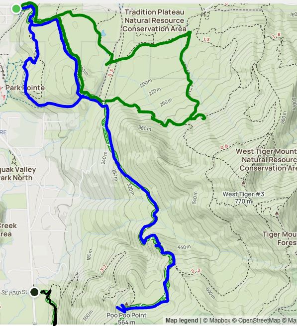
- Hike 1 (blue) …
- Unplanned detour to Park Pointe
- High School, Poo Poo Point trails to the summit of Poo Poo Point
- Return using Poo Poo Point, Adventure and Wetlands trails
- Distance 8.7 miles (14 km)
- Elevation Gain 2,004 ft (611 m)
- Time 3h 30m
- Hike 2 (green) …
- Wetlands, High School and Section Trail to Talus rocks
- Return on Nook, Bus and Wetlands trails.
- Distance 5.6 miles (9km)
- Elevation Gain 1,401 ft (427 m)
- Time 3h 20m
Week 4: Sunol Wilderness
July 23. I don’t think I have been to Sunol Wilderness since walking with Lucy many years ago. Several sections of exposed uphill hiking and high temperatures made this a tough hike (it was 94F by the time I finished. Some great views from the Cerro Este Lookout. I didn’t meet anyone or see any interesting animals/birds on the whole hike. Called in at Mission Pizza for a refreshing glass of Pilsner on the way back. Three days after this hike there was a devastating fire, the Park is now closed indefinitely, so no more hikes here for a while. Facebook posting
- Started from the visitors center parking lot at 8:20AM
- Take the Canyon View, McCorkle trails and Cerro Este Road to the Cerro Este Lookout
- Great views of Calaveras Reservoir
- Take Cave Rocks Road, Eagle View Trail, Vista Valley Road and Flag Hill Road to the top of Flag Hill
- Return downhill on Flag Hill Road and Hayfield Road to the parking lot
- Distance 7.8 miles (12.6 km)
- Elevation Gain 1,826 ft (557 m).
- Time 3h 7m
Week 3: Vargas Plateau
July 16. My first trip to Vargas Plateau. Mostly exposed trails down to Canyon Heights Drive (where we lived from 1987 to 1994) and back uphill. Lots of eagles, and had breakfast with an emu. Only three other hikers on the trail.
- Started from the Vargas Plateau parking lot at 8:15AM
- Hike along Golden Eagle Trail and downhill on Deer Gulch and Cliff Trail to Morrison Canyon Road.
- Return uphill with a short detour to the end of Deer Gulch Trail
- Distance 7.6 miles (12.2 km)
- Elevation Gain 1,259 ft (384 m).
- Time 2h 20m
Week 2: Mission Peak
July 9. Week 2’s training hike was cancelled due to excessive heat warnings in the Bay Area. Temperatures were well over 100F and all inland East Bay Regional parks were closed. I have hiked Mission Peak several times before, but had forgotten how much is uphill. Practically all the way up with that killer section at the peak. Arriving at the peak before 9:30, there were only 2 other hikers there.
- Started from Mission Blvd next to Ohlone College at 8AM.
- Hike South along the Ridge Trail.
- To the Peak where Ridge joins the Stanford trail.
- Return with a short detour South along the Ridge Trail, following a coyote I had spotted from above for 1/2 mile.
- Distance 7.9 miles (12.7 km)
- Elevation Gain 2,142 ft (653 m).
- Time 2h 35m
Week 1: Coyote Hills
June 28. Only 367 days remain before I leave Chamonix on the first day of the hike, training starts now! This hike was mainly flat, apart from the Red Hill trail. Sections of the Alameda Creek Trail and No Name Trail nearest to Coyote Hills were fairly boring, nearer the bay was more interesting with many water birds. Facebook posting
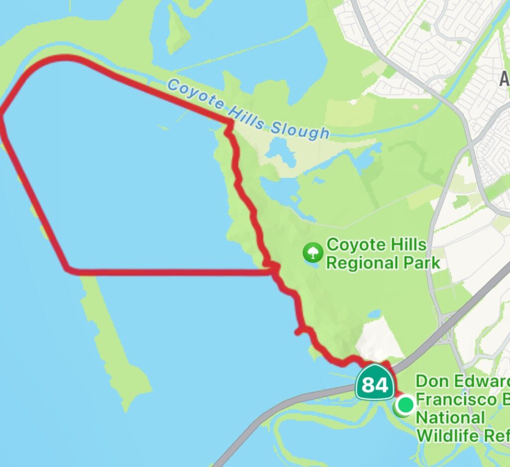
- Started in Don Edwards National Wildlife Refuge parking lot at 9:20AM.
- To the Bay via Apay Way, Red Hill Trail and Alameda Creek Trail.
- Back via Shoreline Trail, No Name Trail and Apay Way.
- Spotted rabbits, jack rabbits, night herons, many other more common birds.
- Distance 10.2 miles (16.4 km).
- Elevation Gain 435 ft (133 m).
- Time 3h.